Typhoon Yagi has intensified and is forecast to reach a maximum wind speed of 166 kilometers per hour (km/h) in the coming days, prompting Prime Minister Pham Minh Chinh to issue emergency preparedness orders.
Typhoon Yagi entered the East Sea on September 3, becoming the third storm in the sea this year, according to the National Center for Hydro-Meteorological Forecasting (NCHF).
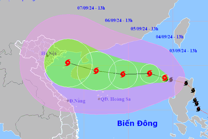
At 13:00 on September 4, Yagi was about 730 km east of China's Hainan Island, with wind speeds of 89-117 km/h, continuing its west-northwest trajectory at 10 km/h.
By 13:00 on September 5, the storm is expected to be about 400 km from Hainan Island, with winds of up to 149 km/h, and will continue to move west-northwest at 10-15 km/h.
By 13:00 on September 6, Yagi is forecast to be in the waters east of Hainan Island with winds of 166 km/h and heading west-northwest at 10-15 km/h.
Forecast track of Typhoon Yagi in the East Sea. Photo courtesy of NCHF |
The storm is expected to maintain a westward path over the next 48 to 72 hours, with further intensification likely. By 7:00 a.m. on September 6, Yagi's eye is expected to be over the eastern waters of Hainan Island, with winds of force 13 and gusts up to force 16.
The northeastern part of the East Sea experienced strong winds and waves of three to five meters from September 3 due to Yagi's impact.
Yagi will most likely affect the sea and the mainland of the northern and north-central regions, according to an urgent directive issued by Prime Minister Pham Minh Chinh on September 3, ordering ministries, sectors, and localities to take immediate measures in response to the typhoon.
The head of the government asked the heads of relevant ministries and localities to keep a close watch on the situation and issue timely instructions on how to respond, ensure the safety of people's lives, and minimize property damage.
The Prime Minister advised coastal provinces to consider closing beaches depending on the situation. Local authorities on land should consider evacuating residents from areas at high risk of flooding and landslides.
Provinces and cities in mountainous areas have been asked to relocate people from landslide-prone areas, ensure the safety of reservoirs and transportation routes, and prepare rescue vehicles for use if necessary.
Coastal provinces from Thanh Hoa to Quang Ninh are advised to reinforce roofs and plan for the evacuation of residents from low-lying and vulnerable areas.
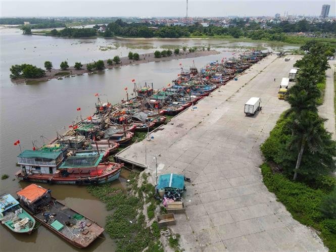
Vessels anchored at Tan Son fishing port in Thai Thuy District, Thai Binh province. Photo: VNA |
The Ministries of Agriculture and Rural Development, Natural Resources and Environment, National Defense, Public Security, Transport, and Industry and Trade are all tasked with implementing response measures.
People are urged to prepare for the storm, while ships at sea are urged to seek safe shelter. It is also necessary to evacuate people from high-risk areas to safer locations and to protect the safety of infrastructure.
The Premier also ordered relevant ministries and localities to prepare forces and vehicles for search and rescue operations. He also asked the media to keep updating on the typhoon's movements and to help guide people in responding to it.
Beginning on September 3, the northeastern waters of the Northeast Sea experienced increasingly strong air currents, reaching force 6, with winds near the center of the storm at force 8-9 and gusts above force 11-12, resulting in rough seas.
Over the following 24 hours, the eastern waters of the Northeast Sea saw waves of 3-5 meters near the center of the storm, and as high as 5-7 meters. The sea was extremely rough and very dangerous for ships.
This is the third tropical storm to hit the East Sea in 2024, after Typhoon Prapiron made landfall in Quang Ninh province on July 23, bringing heavy rains to much of the northern region and killing 14 people.


- Vietnam news in brief - January 22
- Vietnam news in brief - January 21
- Vietnamese leaders congratulate President Donald Trump on inauguration day
- Vietnam, Czech Republic issue Joint Statement on elevating ties to Strategic Partnership
- Vietnam news in brief - January 20
- President calls for overseas Vietnamese to join hands in nation-building efforts


